


Cyclone Mountha Explained: In recent years, India and the surrounding regions of the Arabian Sea and Bay of Bengal have witnessed several powerful tropical cyclones. One such storm that recently caught attention is Cyclone Mountha — a tropical storm that developed over the Arabian Sea. But what exactly is Cyclone Mountha, and how do such massive storms form over the ocean?
Let’s understand in detail how cyclones are born, what makes them dangerous, and how they are tracked.
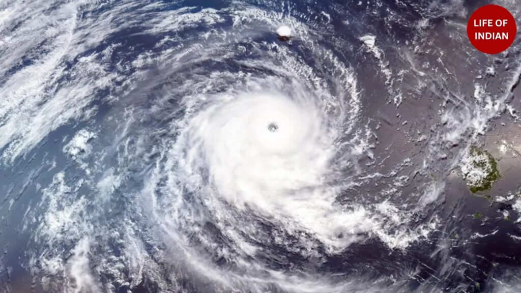
What Is Cyclone Mountha?
Cyclone Mountha is a tropical cyclone that developed over the Arabian Sea, one of the two major basins around India where cyclonic systems frequently form (the other being the Bay of Bengal).
The name “Mountha” was given according to the rotational naming system of tropical cyclones used by countries in the Indian Ocean region — including India, Bangladesh, Maldives, Oman, Pakistan, Sri Lanka, and others.
Each member country submits a list of names in advance, and the World Meteorological Organization (WMO) assigns them sequentially when a new system develops.
Mountha, like other tropical cyclones, formed due to a combination of warm ocean waters, low air pressure, and strong wind circulation, which gradually developed into a severe storm.
How Do Cyclones Form in the Ocean?
A cyclone is a large-scale air mass that rotates around a strong center of low atmospheric pressure. In tropical regions, cyclones are fueled by heat and moisture from warm ocean waters.
Here’s a step-by-step explanation of how they form:
1. Warm Ocean Water (Above 26°C):
The primary condition for cyclone formation is warm sea surface temperature. When the water temperature rises above 26–27°C, it begins to heat the air above it.
2. Evaporation and Moist Air:
The warm water causes evaporation, sending moist air upward. This rising air cools and condenses, forming thick clouds and releasing latent heat — which further powers the system.
3. Low Pressure at the Surface:
As the warm, moist air rises, it creates a low-pressure zone near the ocean surface. Surrounding air rushes in to fill the gap, creating strong winds and circular motion due to the Coriolis effect (the Earth’s rotation).
4. Organization of the Storm:
Gradually, the system becomes more organized, with a well-defined eye (center) and spiral rainbands.
The winds begin rotating faster around the eye, and the storm intensifies into a tropical cyclone.
5. Intensification and Landfall:
As long as the cyclone remains over warm waters, it continues to draw energy and grow stronger.
When it moves toward land, the cyclone weakens due to loss of moisture source and friction from the land surface, but it can still cause heavy rainfall, storm surges, and flooding.
Categories of Cyclones in the Indian Ocean
The India Meteorological Department (IMD) classifies cyclones in the North Indian Ocean region into different categories based on wind speed:
| Category | Wind Speed (km/h) | Impact |
|---|---|---|
| Depression | 31–49 | Light rainfall, minor wind |
| Deep Depression | 50–61 | Moderate rainfall, gusty winds |
| Cyclonic Storm | 62–88 | Heavy rain, flooding risk |
| Severe Cyclonic Storm | 89–117 | Strong winds, coastal damage |
| Very Severe Cyclonic Storm | 118–165 | Widespread destruction |
| Extremely Severe Cyclonic Storm | 166–220 | Major coastal devastation |
| Super Cyclone | >221 | Catastrophic damage |
Why Do Cyclones Form Mostly in the Arabian Sea and Bay of Bengal?
India is surrounded by the Arabian Sea on the west and the Bay of Bengal on the east — both are warm-water bodies ideal for cyclone formation.
However, the Bay of Bengal sees more cyclones than the Arabian Sea because:
-
It receives more heat and humidity due to river inflows and monsoon winds.
-
The Coriolis force (which causes rotation) is stronger in that region.
-
The sea surface temperature remains higher for a longer time.
But in recent years, the Arabian Sea has also started witnessing more intense cyclones, including Tauktae (2021), Biparjoy (2023), and now Mountha (2025), due to climate change and rising sea temperatures.
Climate Change and Cyclone Intensity
According to climate scientists, the frequency and intensity of tropical cyclones in the Arabian Sea have increased significantly in the last two decades.
Rising sea surface temperatures provide more energy to storms, making them stronger and longer-lasting.
For example, cyclones that earlier lasted 2–3 days are now sustaining for 5–7 days, with wind speeds crossing 200 km/h in some cases.
This trend is linked to global warming, changing monsoon patterns, and warming of deep ocean layers.
Dangers of Cyclones
Cyclones can cause devastating damage, especially to coastal regions.
Their impacts include:
-
Storm surges: Sudden rise in sea level that floods coastal areas.
-
Strong winds: Destroy houses, trees, and power infrastructure.
-
Heavy rainfall: Causes flash floods and landslides.
-
Disruption of livelihood: Fishing and agriculture suffer the most.
Preparedness, timely evacuation, and improved weather forecasting have helped reduce human losses in recent years, but economic damage remains significant.
How Are Cyclones Detected and Tracked?
The India Meteorological Department (IMD) and ISRO satellites continuously monitor the Arabian Sea and Bay of Bengal for low-pressure formations.
Advanced technologies like:
-
INSAT weather satellites
-
Doppler Radar systems
-
Numerical weather prediction models
help predict cyclone formation 3–5 days in advance, allowing governments to issue timely warnings and evacuate coastal populations.
Cyclone Mountha is yet another reminder of how powerful nature can be — and how deeply the ocean and atmosphere are interconnected.
Cyclones are a natural part of the Earth’s climate system, but climate change is making them stronger and more unpredictable.
Understanding how these storms form helps us appreciate both the science behind them and the importance of preparedness.
With accurate forecasting, community awareness, and sustainable coastal management, we can reduce the devastation these mighty storms bring.